The National Parks of Utah
Southern Utah is one of the most beautiful parts of the United States. So much so that it has five National Parks, from A to Z:
- Arches National Park
- Bryce Canyon National Park
- Canyonlands National Park
- Capitol Reef National Park
- Zion National Park
In addition to these amazing national parks, there are almost countless National Forests, National Recreation Areas, State Parks, and local parks. This really makes driving between them a treat, with a diversity of scenery ranging from hot deserts with alien hoodoos to mountain forests and lakes more reminiscent of the high Sierras.
From anywhere in the country, it’s easy to fly into Las Vegas and begin your tour with a three hour drive to Zion National Park in southwestern Utah. A route that I highly recommend:


In practice, this route took closer to 1700 miles if you include transit time from towns/hotels to and from the parks — with Canyonlands being the most driving by a long shot; entering the northern Island in the Sky district was about 45 miles to Moab, and the more isolated southern Needles district closer to 60 miles away. You can easily stay under 10 miles away from Arches, Bryce, Zion, and Capitol Reef. If you’re lucky and can snag a camping spot in the parks, you’ll be able to cut out much of the driving. The southern route from Moab (Arches, Canyonlands) to Torrey (Capitol Reef) is not the fastest route, but you won’t want to miss the Scenic Bypass of Route 95.
Zion National Park

Closest to Las Vegas, Zion is an ideal start for your trip. During the high season, you need a permit to drive in the park. They operate a free shuttle that stops at nine popular points in the canyon. However this shuttle can get crazy busy. Arriving at 7:30am on Memorial Day, the wait was 15 minutes. If we had arrived at 7:45am, the wait would have been over 30 minutes. So go early if you plan to hit Zion’s showstopper, Angel’s Landing:

It’s a pretty reasonable trail for the first two miles up, switchbacks and such. But the last half mile is a very technical rock climb with precipitous drop offs on both sides. There are chains strung between posts for almost all of that last pitch, and you’ll need them. I also recommend one hiking pole (not two) to assist your climb. At the top you’ll be rewarded with a spectacular view:

Because of its reputation, you can expect this trail to get crowded. And since the last half-mile pitch is roughly single file, traffic backups will slow you down big time. If you hit the trailhead at 8am, you can spend 20–30 minutes at the top and make it back down by 11am. If you go any later, it will take 4+ hours — and in the summer, that will be during the hottest part of the day.
If Angel’s Landing isn’t your speed, even the paved Par’us trail starting at the Visitor Center has amazing landscapes:

In fact, if there’s a long line for the shuttle, I’d say your best bet is to skip the line and take the Par’us trail to shuttle stop one or two. Or even walk beyond to three or four. Like the cable cars in San Francisco, it’s much easier to get on at any stop other than the first one.
Arches National Park
If you’ve only got time for one National Park, it may well be this one. The park entrance is a mere seven miles from the reasonably sized town of Moab. Arches’ Delicate Arch is famous for being featured on the Utah state license plate:

The morning is less crowded, but the evening lighting is better. Either way, it’s worth the 4 mile round trip. The last bit is all slickrock, so non-slip soles will go a long way toward your stability and sanity.
Delicate Arch gets a lot of the credit at this park, but there are literally hundreds of arches and hoodoos, and many of the impressive ones are just a short hike from the trailhead on the side of the road.


Admittedly, Arches isn’t much of a park for hikers. And that’s one reason Devil’s Garden is so special. It’s one of the best dusk hikes I’ve ever gone on:


That 8 mile roundtrip will take 3–4 hours. If 8 miles sounds daunting, 4 hours is enough time for 3–4 other arches, towers, or balanced rocks that are less than a mile roundtrip. A day and a half is about as long as you need to hit 80% of the highlights.
Canyonlands National Park
The largest national park in the United States, and also one of the least crowded and hardest to get to. There are three distinct districts: Island in the Sky to the north, Needles to the south, and Maze to the west. They’re disconnected within the park; driving from Island in the Sky to Needles requires exiting the park, driving on the highway, and re-entering from the south — a four-hour detour!
Canyonlands: Island in the Sky
From Moab, it will take you about an hour of driving (at least there’s no traffic!) to make it to Mesa Arch, the first point of interest in the Island in the Sky district to the north:

Mesa Arch is only half a mile from the trailhead and won’t take that long. There’s really only one thing to see there! If you’re yearning for a better view of the canyon (you will be), you can then proceed to Grand View:

The lighting on the east side of the canyon is really best before 11am. Later in the day, the western side shines:

The Murphy Point Overlook trail is a quick 4 mile round trip, and is perfect for sunset — especially considering it will take about an hour of driving in the darkest dark you’ve seen to get back to Moab.
Canyonlands: Needles District
If you’re looking for something a little more remote, even more so than southern Utah is, you can’t pass up the Needles district of Canyonlands. With Moab as a launch point, it’s about 60 miles south on the highway and then west to the entrance. Once you get into the park, you might have another dozen miles to go on single-lane dirt roads to get to your trailhead. Allow for time accordingly to drive there and return.
You’ll be rewarded with stunning landscapes and rock formations, with very few other people on the trail. The Chesler Park hike is an excellent ~4 hour round trip that takes you from the Elephant Road trailhead up, and down, and up finally reaching a scenic overlook (in the shade!).

In the summer Needles is much warmer than Island in the Sky, so plan accordingly: sunscreen, a hat (or umbrella!), plenty of water, and if at all possible, as early or late in the day as you can. It’s hard to believe some people start hiking at mid-day in 100F temperatures.
Canyonlands to Capitol Reef
The fastest route to Capitol Reef is to take the highway back to I-70 west and cut south, but you’d miss one of the most beautiful scenic byways I’ve ever seen: Utah State Route 95. This two hour drive from Blanding to Hanksville is a stunning tour of red rocks, canyons, and a bridge over the Colorado River.

Don’t expect much other than scenery though; there are virtually no service stops along the way. But I can’t imagine a better way to get to Capitol Reef National Park.

Capitol Reef
If you asked a National Park aficionado to list the five national parks in southern Utah, Capitol Reef is the one they would be most likely to forget. Its name isn’t as obvious as Arches or Canyonlands either; Capitol comes from the white mountain with a button on top that looks like the Capitol dome in Washington D.C., and reef just means barrier — named as such because the mountains here were a great barrier for early settlers moving west.
The mountains are so gnarly because Capitol Reef’s Waterpocket Fold is a monocline, where a geologic fault bent the rock strata upward. The rock layers on the western side of the fold are about 7000 feet higher than the same strata on the eastern side.

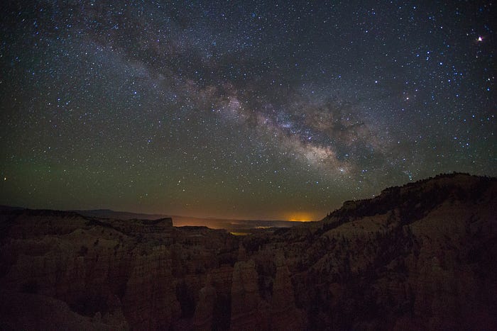
Today the area is much easier to access. In fact, the closest town of Torrey is only about seven miles west of the park itself. In addition to the “standard” arches, cliffs, and canyons of southern Utah, Capitol Reef also contains some historic buildings from the old town of Fruita. If Milky Way photography floats your boat, Capitol Reef is an international dark sky park and offers stunning foregrounds:

Because of the scenery, lack of life pollution and easy access from Torrey, Capitol Reef is one of my favorite spots for Milky Way photography.
If you’re not much of a night owl (Milky Way is best seen after midnight), there’s a short hike to Cassidy Arch, named after the outlaw Butch Cassidy. And what a hideout! There’s now a well-blazed and cairned trail, but it’s certainly not an easy home to return to. Additionally, the slickrock in the mile before the arch has no sand and your steps leave no footprints to track. The trailhead is also a wash area prone to flash floods, which adds another degree of peril.

The wash area also offers the most diversity of rocks (quartz, etc) compared to the other parks of Utah.
Bryce Canyon
One of the premier parks of Utah, Bryce Canyon is understandably more visited and crowded than Capitol Reef or Canyonlands. Accommodations can be found about 4miles south of the park entrance. The showstopper of Bryce is certainly the Amphitheater:

The rock formations are reminiscent of a city skyline, with clusters of varying height hoodoo-skyscrapers. The aptly named Sunrise and Sunset Points offer the most breathtaking vistas. You don’t have to be there just at sunrise and sunset though. In fact, Sunset point is probably better in the two hours preceding sunset, when the hoodoos are still well-lit with warm light:

The Rim Trail is a short half-mile hike between the two points, but you’ll almost certainly want to hit up the Queen’s Garden/Navajo Loop — often called the best 3-mile hike in the United States. This trail winds down into the amphitheater and brings you up close and personal to many of the hoodoos, arches, and other rock formations.

As another international dark sky park, Bryce Canyon is a stunning foreground for the Milky Way:
Fairyland Canyon is technically not in Bryce Canyon National Park, located just a mile south of the park entrance. Which also makes it a ~5 minute drive from the nearby hotels: perfect for sneaking out to the overlook for and setting up a tripod for some long-exposures.

When you explore the park during the day by car, most of the scenic overlooks are on the eastern side of the road. As such, it’s a lot easier to visit them sequentially if you drive to the end of the 16-mile park road and work backwards — all the scenic pull-outs will be on your right.


Photography tips
To capture the vast landscapes, a wide angle lens is a necessity. I mainly used a Canon 16–35mm f/2.8 L lens, but also a 28–135mm f/3.5–5.6 for zooming in on rocks in the distance. The 16–35mm is a higher quality lens (the L is for le Expensive) and was noticeably sharper. During most of the day, you’ll have a ton of light and can play with sunbursts at high apertures (like f/18).
For Milky Way photography, your day hikes can double as scouting trips for foregrounds. When you have a few locations in mind, look them up on lightpollution.info. When you know the general area you’ll be shooting, use stellarium, the planetarium for your laptop, to find when and where the Milky Way will be rising. If it’s a new moon, you can shoot all night — otherwise, you’ll need to work around the moon rising and setting for the sky to be dark enough. A guide to the technical aspect of Milky Way photography is beyond the scope of this post, but the Cliff’s Notes are:
- wide angle lens
- lowest f-stop available (i.e. widest aperture)
- focus on infinity (not beyond)
- ISO 1600+
- 8–30 second exposure
It’s important to remember that most lenses can focus past infinity, so don’t manually focus to the maximum. If you’ve got a Canon lens, you can set the focus mark to the vertical line in the ‘L’.
While camera drones are banned at all National Parks, the scenery near national parks can be just as stunning — especially from 300 feet in the air. If you plan to pilot a drone, please follow all standard FAA regulations.
All of my pictures can be found at Utah National Parks on Flickr.